|
|
 |
This
is What we are Fighting For
Here
it is (or more accurately, here it was). We neighbors
had always assumed that the creek - Lick Creek - our creek
would perpetually be
a perfectly pristine piece of paradise - the spiritual
centerpiece of our neighborhood.
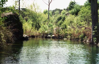
This
photo by Pam Wendell is what Lick Creek looked like just
one year ago, when it still ran crystal clear, as it
had
run since
the
tapir and dire wolf drank its cool waters.
Herbert
Alexander Jr. of the Department of Anthropology, The University
of Texas, Austin, led a team of volunteers in a series
of excavations in 1959-60 at the Levi rock shelter near
the mouth of Lick Creek.
|
|
Dr.
Alexander reported in the April, 1963 issue of American
Antiquity that
the team had "...uncovered several artifact types previously
unknown in Paleo-Indian
cultures." They discovered a wide variety of tools left
by human inhabitants of the area approximately 10,000
years ago.
Plainview,
Clovis and Angostura points were found, along with burins,
burin spalls, scrapers and prismatic blades.
For
more information about the anthropology and geology of
the Creek, go to the History page. |
 |
|
 |
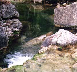
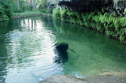
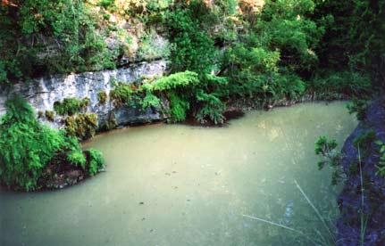
Pictured
above, and in the photo on the left by Pam Wendell, are the
Green Hole, also known as the Cave Hole, and the pool downstream
from the Green Hole. This is what the water
looked
like
before
the
West
Cypress Hills subdivision started construction upstream.
You could see the bottom over much of the pools' surfaces.
The water was so clear you had to hold yourself back from
drinking it. |
|
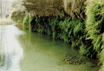
Here
is another shot showing the fantastic clarity the Green
Hole used to have. This photo is by noted photographer
Rick Williams, who used to live in these parts but now
resides
in Eugene, Oregon. Rick took this picture in the Summer
of 2003.
|
|
|
|
This
photo by Cindy Phillips shows what the "Green" Hole
looked like on July 27, 2004, after a heavy rain caused
gobs of silt to overflow from the West Cypress Hills subdivisions "detention
pond". Want a drink? We didn't think so.
The
hole and the east branch of the creek that feeds it have
looked murky and cloudy like this after every major rain
event since the subdivision's construction began. |
|
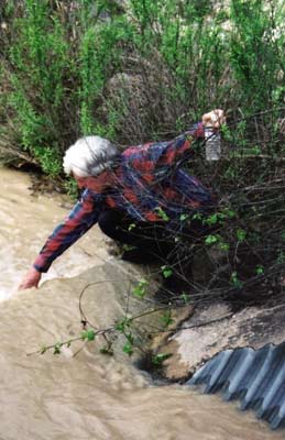 |
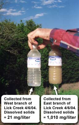
Engineer
and long-time Lick Creek landowner Jim Phillips took water
samples from both
the east and
west branches of Lick Creek on April 6, 2004. Here, he is
collecting, at the low water crossing, from the nasty
East branch. The
bottle
of clear water Jim holds in his left hand is from the
unspoiled West branch, which does not run through West Cypress
Hills. |
 |
|
 |
And here is that same low water crossing, in a
photo Cindy Phillips shot on July 27, 2004, fouled by West Cypress
Hills pollution.
|
|
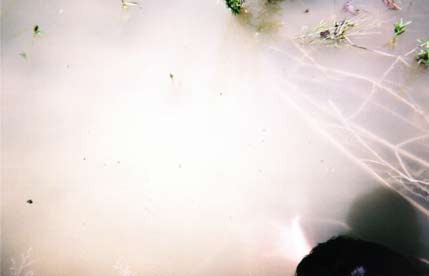
Here
it is up close and personal. Taken by Pepper Morris on April
8, 2004, this ugly, silty mess is what creek becomes periodically
now.
This
sort of devastation must be stopped. Nature needs her creek
back and so do we.
Please
help us in our struggle to return Lick Creek to its former
perfection. Go to the Action page
to find out how. |
 |
|
| If you haven't had enough (which would make you a glutton for punishment)
you can view more pictures of the seriously polluted creek (as it
has been after each rain event since April) by going to the Gallery
of Shame. |
|
|